


By buying this product you can collect up to 16 Citimarine points. Your cart will total 16 points that will be converted into a voucher of $1.60 towards your next purchase! Must be logged in to collect points.
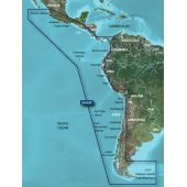
HSA001R - South America East Coast - BlueChart 2g HD allows you to see your vessel’s precise, on-chart position in relation to navaids, coastal features, anchorages, obstructions, waterways, restricted areas and more with this detailed marine mapping data. Coverage of the east coast of South America from the Golfo de Paria to Tierra del Fuego.
MFG#: 010-D1028-00
HSA001R - South America East Coast - BlueChart 2g HD allows you to see your vessel’s precise, on-chart position in relation to navaids, coastal features, anchorages, obstructions, waterways, restricted areas and more with this detailed marine mapping data.