
By buying this product you can collect up to 29 Citimarine points. Your cart will total 29 points that will be converted into a voucher of $2.90 towards your next purchase! Must be logged in to collect points.
Reveal Ultra High Resolution Bathymetric Chart US Atlantic VA - Jacksonville
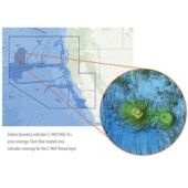
C-MAP Reveal Ultra High Resolution Bathymetric Chart US Atlantic VA - Jacksonville. Ultra High-Resolution bathymetric imagery sea floor layer added to existing MAX N+ data content to clearly identify the sea floor structure, as well as wrecks, isolated reefs and ledges in between the contour lines to find the best diving and bottom fishing spots for sport fishing and diving markets.
Reference: M-NA-Y642-MS
$299.00
Free Shipping on Orders over $99
*On Orders Over $99; Not including: Hazardous, Oversize, Greater than (+150 lbs.) or Freight Advertised Products. FEDEX Ground Shipping / Continental US Only
Shipping Calculator
C-MAP Reveal Ultra High Resolution Bathymetric Chart US Atlantic VA - Jacksonville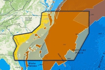
Features
Traditional Navigation (vector) data
HRB (High Res Bathy) Coastal data
Satellite Imagery data
Genesis layer data
Replaces the SHADED RELIEF data in the covered area
Selectable by the MFDs software setting SHADED RELIEF ON
Displayed in color shading![]()
Other Models